FrameworkBehind
The LEADS MRV Framework provides a structured approach to accreditation and verification for carbon credits in climate-smart rice farming.
It incorporates remote sensing, IoT-based GHG monitoring, and AI-driven analytics to systematically track key farming practices such as water management (AWD), tillage, crop rotation, and residue handling.
Developed in collaboration with SEARCA and international certifiers, the framework follows a multi-tiered verification process to align with global carbon market standards.
Verified and Research-BackedPractices
A foundation of science and collaboration.
Scientific Validation
All monitored variables, from GHG emissions to water use and soil health, are measured using methods validated by peer-reviewed research.
Our in-house scientific team ensures all protocols align with international Digisaka Carbon Credits standards.
Collaborative Expertise
Partnerships with government agencies, academic institutions, and global research networks reinforce the credibility of our methodologies.
We integrate local knowledge and indigenous farming techniques, ensuring that the technology is not only data-driven but also contextually relevant to the realities of Filipino agriculture.
Why It Matters
From farms to carbon markets, trust is in the details.
Our monitoring ensures accuracy, timeliness, and spatial detail, critical for validating Digisaka Carbon Credits.
Farmers gain access to carbon markets with the confidence that their practices meet global standards.
Verified data fosters trust among investors, buyers, and regulators.
Advanced AgriculturalMonitoring Solutions
Comprehensive emission tracking and agricultural practice monitoring through ground-based precision sensors and remote sensing technology.
- IoT-enabled sensors for real-time data collection on methane (CH₄) and carbon dioxide (CO₂) emissions
- Field-level tracking of essential agricultural practices such as Alternate Wetting and Drying (AWD), tillage, and residue management
- Gold-Standard Calibration: Our remote sensing methodologies are validated using gas chromatography, flux towers, and in-field emission sampling
- Collaboration with national and international research partners to ensure the highest accuracy
- Satellite imagery and AI-powered data analysis to provide spatial and temporal insights on farming practices and emissions
- High-resolution mapping ensures every hectare is accounted for
- We rely on satellite imagery, UAV data and machine learning models to analyze agricultural variables
- Our AI-driven system minimizes uncertainty from low-quality data inputs, avoiding the 'garbage in, garbage out' problem
Our SensorTechnologies
Cutting-edge hardware solutions designed for precision monitoring in challenging agricultural environments.
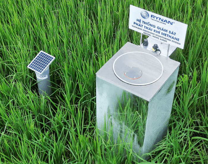
MethanEye™ PY100
Autonomous methane monitoring system with automatic chamber operation and real-time data transmission.
Smart methane monitoring with high-accuracy sensors
4G data transmission to mobile devices
Supports climate change mitigation and sustainable agriculture
AWD+ of Rynan Technologies
Precision water level monitoring for Alternate Wetting and Drying practices, optimizing water usage while reducing methane emissions.
Submersible water level detection (±1mm accuracy)
Soil moisture and temperature monitoring
Reduces water usage by 15-30%

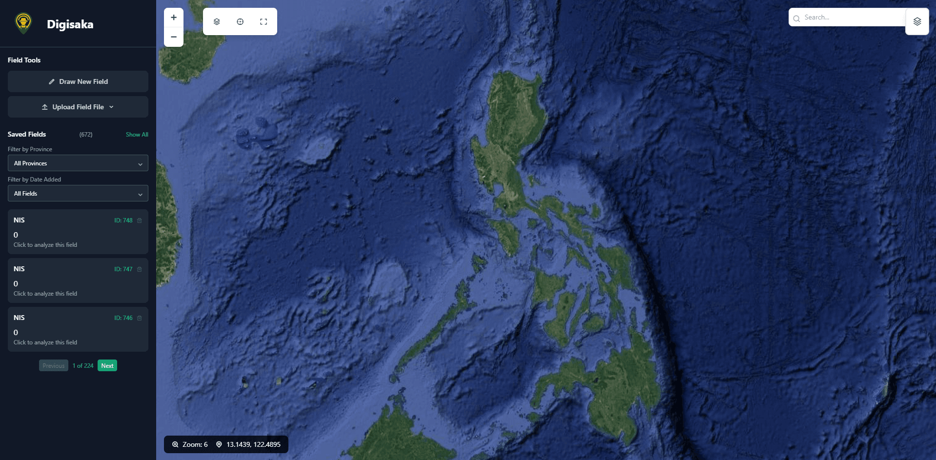
Digisaka Platform
Web-Based Interactive GIS & Remote Sensing Software for Comprehensive Crop Monitoring
Interactive GIS
Advanced geographic information system tools for precise field mapping and analysis
Remote Sensing
Real-time satellite imagery and data analysis for comprehensive crop monitoring
Crop Monitoring
Track crop health, growth stages, and environmental conditions in real-time
Loading Digisaka...
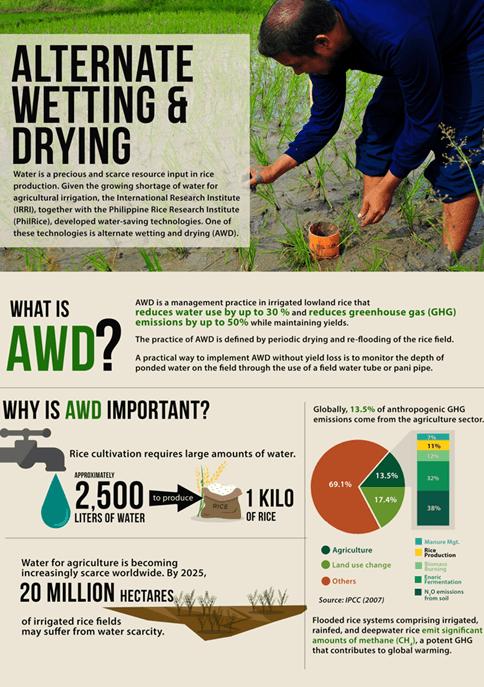
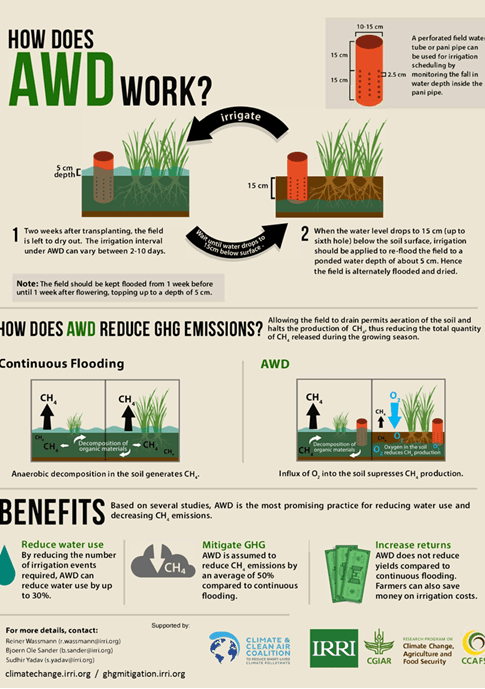
What is AWD?
Alternate Wetting and Drying (AWD) is a water-saving technology for rice production that reduces methane emissions and supports climate-smart, low carbon farming.